- Contact 0870 350 7767
- |
- Advertise

Home > DTM Technologies > Laser surveys to digital drawings for planners and Architects
Laser surveys to digital drawings for planners and Architects
 News and PR from DTM Technologies - Published 19 January 2016
For a limited time we are offering our laser scanning services with 30% off the normal price, contact us here for details. The reason for our service at a reduced cost is to help illustrate what we can do. We will also provide a free consultation session in order to answer any questions regarding Laser scanning and how the data can be used in your workflow
News and PR from DTM Technologies - Published 19 January 2016
For a limited time we are offering our laser scanning services with 30% off the normal price, contact us here for details. The reason for our service at a reduced cost is to help illustrate what we can do. We will also provide a free consultation session in order to answer any questions regarding Laser scanning and how the data can be used in your workflow
Laser scanning is fast becoming part of the everyday surveying workflow. The information collected in the form of a point cloud is highly accurate. The biggest hurdle with point cloud data, is not the storage, which was a problem as little as five years ago (A typical site scan can be many gigabytes), but its what is it used for other than extracting information from it, with the propriety software that the scanner uses.
So the question is, why employ us? Our background is not surveying, its 3d visualisation. Technology has thrown the act of digital data acquisition and traditional 3d visualisation together, it was inevitable, they are made of the same stuff, POINTS IN 3D SPACE, modelling is just joining the dots, seems simple enough, but alas nothing is that simple.
We at DTM Technologies have developed workflows and strategies that can manipulate point cloud data and create visualisation products suitable for the surveyor, the architect, the scientist, the planner, the environmentalist, the archaeologist, the list is endless.
We have the equipment, we have the skills. To hire our scanning services and/or our skills, give us a call or contact us here and lets talk.

 Capture a building or structure accurately (<5mm) in one visit take it back to the office for post processing

Other announcements from DTM Technologies
-
3D Printing and Casting
Digitally created models, 3d printed, from this we create moulds for casting in high quality resins, ideal for bespoke art & design work, ornamental and engineering.
19 Jan 2016
-
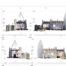
Llaneilain Church, Anglesey - Measured Laser Survey
Laser scanning at an historic Church on the Isle of Anglesey. Interior and exterior captured in one day, all ready for further processing in the office.
19 Jan 2016